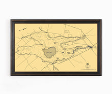
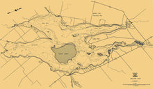
This map of Balsam Lake in the Kawartha Lakes region is from a series of bathymetric maps produced by the Ontario Ministry of Natural Resources. It is from the 1960's and is an excellent example of depth chart maps from this period.
Balsam Lake is the highest point of the Trent–Severn Waterway and from here, the waterway descends to Georgian Bay in the northwest, and to Lake Ontario in the southeast. It is the highest point to which a vessel can be navigated from sea level in the Great Lakes-Saint Lawrence River drainage basin.
(Please refer to FAQ's for more info and pictures.)
- Paper-Hahnemuhle Archival, heavyweight and thick 240g 100% cellulose, warm white art paper with a smooth matte surface. Perfect for framing.
- Canvas-Gallery wrapped using heavyweight 400g, archival canvas. It's protected with a satin varnish, and stretched around a 1.5 inch pine wood frame, ready to hang.


