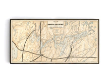
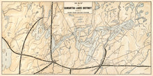
This map was difficult to track down!
Sourced from turn of the century marketing materials from the Grand Trunk Railway, this hand-drawn map of the Kawartha Lakes region is a unique piece of history. The map details the various lakes and rivers of the area as well featuring an interesting dotting, textured approach to indicate geographic relief. The map features cities and towns such as Peterborough, Lakefield, Bobcaygeon, and Lindsay, as well as the travel routes by rail and road, are pictured
(Please refer to FAQ's for more info and pictures.)
- Paper-Hahnemuhle Archival, heavyweight and thick 240g 100% cellulose, warm white art paper with a smooth matte surface. Perfect for framing.
- Canvas-Gallery wrapped using heavyweight 400g, archival canvas. It's protected with a satin varnish, and stretched around a 1.5-inch pine wood frame, ready to hang. A floater frame can be added as an option to canvas print purchases.
Have something specific in mind but don't see it in the available options? We can facilitate almost any request, just drop us a line to info@grandtrunktrading.cowith details and any appropriate links to reference and we'll get back to you!


