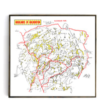
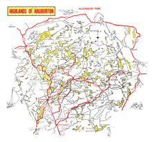
Welcome to the Haliburton Highlands! Vintage maps of this prime area of Ontario cottage country have been very difficult to find so we are very excited to share this whimsical, illustrated map of the entire region. This 1960's era map features the hundreds of lakes and river systems that define the highlands, as well as the major roadways, towns and fun illustrations of some of the many of the sporting and leisure pursuits in the area.
Based on our experience this map will show best as a printed and framed canvas due to the generous use of whitespace and high contrast colours. Another great cottage look is using our hand-made walnut hanging rail system to showcase a canvas print. If you have a specific size, spec or colourway requirement, please do not hesitate to get in touch with us.
(Please refer to FAQ's for more info, shipping details and more pictures on product options.)
- Paper-Hahnemuhle Archival, heavyweight and thick 240g 100% cellulose, warm white art paper with a smooth matte surface. Perfect for framing.
- Canvas-Gallery wrapped using heavyweight 400g, archival canvas. It's protected with a satin varnish, and stretched around a 1.5 inch pine wood frame, ready to hang.


