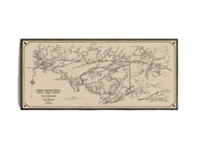
This beautifully restored 1919 map showcases the railway, lakes, canoe routes, infrastructure, and diverse flora and fauna of this pristine northern region.
At 1.2 million acres (4,758 square kilometers), Quetico Provincial Park is Ontario's second-largest wilderness park. For thousands of years, Quetico has served as a travel corridor for native peoples and, more recently, as one of the main routes to the west for European explorers and fur traders.
In 1913, the Quetico Forest Reserve of Ontario DPW became the Quetico Provincial Park under the Ontario Department of Lands, Forests, and Mines. Trapping, commercial fishing, mining, and logging were still allowed within its boundaries, but concerned by the destruction of the wild character of Minnesota and Ontario, the US formed the Quetico Superior Council, which was established to obtain a treaty between the US and Canada "to defend and extend the roadless wilderness area along the boundary waters and to protect and expand the rare public values in Rainy Lake watershed."
(Please refer to FAQ's for more info, shipping details and more pictures on product options.)
- Paper-Hahnemuhle Archival, heavyweight and thick 240g 100% cellulose, warm white art paper with a smooth matte surface. Perfect for framing.
- Canvas-Gallery wrapped using heavyweight 400g, archival canvas. It's protected with a satin varnish, and stretched around a 1.5-inch pine wood frame, ready to hang. (No exterior frame)


